


Schlucht Hohnech Collet

domiweb88
User
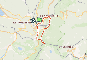

Length
8.7 km

Max alt
1355 m

Uphill gradient
293 m
Km-Effort
12.6 km

Min alt
1108 m

Downhill gradient
291 m
Boucle
Yes
Creation date :
2021-02-21 09:25:53.463
Updated on :
2021-02-21 13:20:48.571
3h54
Difficulty : Very easy

FREE GPS app for hiking
 SityTrail
IGN / Geographical institutes
SityTrail Plus
The world is yours!
About
Trail Walking of 8.7 km to be discovered at Grand Est, Vosges, Le Valtin. This trail is proposed by domiweb88.
Positioning
Country:
France
Region :
Grand Est
Department/Province :
Vosges
Municipality :
Le Valtin
Location:
Unknown
Start:(Dec)
Start:(UTM)
351292 ; 5324318 (32U) N.
Comments